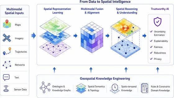
GeoAI Foundations and Multimodal Spatial Intelligence

Developing fundamental GeoAI methods for spatial representation learning, geospatial data and knowledge engineering, multimodal spatial information extraction, spatial reasoning, and trustworthy AI across maps, imagery, trajectories, networks, text, and sensor data.

GeoAI Foundations and Multimodal Spatial Intelligence

Transportation, Mobility, and Network Intelligence

Developing AI and data-driven methods for real-time mobility sensing, traffic information extraction, multimodal traffic data integration, forecasting, routing, navigation, network analytics, intelligent location-based services, and scalable citywide systems.

Transportation, Mobility, and Network Intelligence

AI-Enabled Spatial Problem Solving for Urban Challenges

Integrating multidisciplinary spatial data, domain models, and AI methods to address scientific questions and societal challenges in resilience, health, environment, population dynamics, migration, logistics, urban services, sustainability, and policy decision support.

AI-Enabled Spatial Problem Solving for Urban Challenges

Spatial Optimization and Scalable GeoAI Systems

Developing spatial optimization methods and scalable GeoAI systems for real-world decision-making, including graph and network optimization, road-network partitioning, routing, resource allocation, service-area design, human-in-the-loop decision support, edge-cloud deployment, and production-level GeoAI through industry and government partnerships.

Spatial Optimization and Scalable GeoAI Systems