Multivariate Mapping and Geovisualization with SOMVIS
Introduction
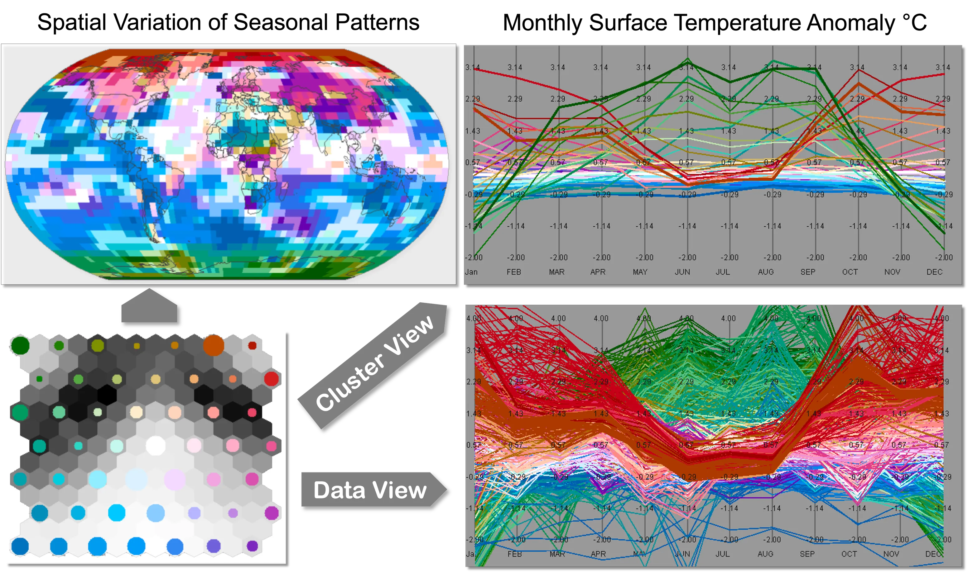
SOMVIS integrates computational analysis, interactive visualization, and cartographic representation to discover and interpret multivariate spatial patterns. It uses a Self-Organizing Map (SOM) to reduce dimensionality and organize large datasets into clusters, encodes their similarities through a coordinated color scheme, and links geographic maps with parallel coordinate plots. Interactive exploration allows users to examine statistical patterns in their geographic context, combining computational pattern discovery with human interpretation.
Applications of SOMVIS and its related visual-analysis methodology span urban research, architecture, economic geography, environmental science, and the humanities. Examples include characterizing building stocks for vulnerability assessment, comparing regional industry composition, interpreting seismic facies, and mapping linguistic variation. By revealing how places differ across many attributes, the approach supports scientific inquiry and offers opportunities to investigate neighborhood characteristics, urban change, and service needs.
Related Publications
Multivariate Analysis and Geovisualization with an Integrated Geographic Knowledge Discovery Approach. Cartography and Geographic Information Science , 32(2), 113–132
BibTeX
@article{guo2005multivariate,
  author = {Guo, Diansheng and Gahegan, Mark and MacEachren, Alan M. and Zhou, Biliang},
  title = {Multivariate Analysis and Geovisualization with an Integrated Geographic Knowledge Discovery Approach},
  journal = {Cartography and Geographic Information Science},
  year = {2005},
  volume = {32},
  number = {2},
  pages = {113--132},
  publisher = {Informa UK Limited},
  doi = {10.1559/1523040053722150},
  url = {https://doi.org/10.1559/1523040053722150},
} A Visualization System for Space-Time and Multivariate Patterns (VIS-STAMP). IEEE Transactions on Visualization and Computer Graphics , 12(6), 1461–1474
BibTeX
@article{guo2006visualization,
  author = {Guo, Diansheng and Chen, Jin and MacEachren, Alan M. and Liao, Ke},
  title = {A Visualization System for Space-Time and Multivariate Patterns (VIS-STAMP)},
  journal = {IEEE Transactions on Visualization and Computer Graphics},
  year = {2006},
  volume = {12},
  number = {6},
  pages = {1461--1474},
  publisher = {Institute of Electrical and Electronics Engineers (IEEE)},
  doi = {10.1109/tvcg.2006.84},
  url = {https://doi.org/10.1109/tvcg.2006.84},
} Multivariate Spatial Clustering and Geovisualization. Chapman & Hall/CRC Data Mining and Knowledge Discovery Series
BibTeX
@incollection{guo2009multivariatespatialclu,
  author = {Guo, Diansheng},
  title = {Multivariate Spatial Clustering and Geovisualization},
  booktitle = {Chapman \& Hall/CRC Data Mining and Knowledge Discovery Series},
  year = {2009},
  pages = {325--345},
  publisher = {CRC Press},
  doi = {10.1201/9781420073980.ch12},
  url = {https://doi.org/10.1201/9781420073980.ch12},
} Flow Mapping and Multivariate Visualization of Large Spatial Interaction Data. IEEE Transactions on Visualization and Computer Graphics , 15(6), 1041–1048
BibTeX
@article{guo2009flow,
  author = {Guo, Diansheng},
  title = {Flow Mapping and Multivariate Visualization of Large Spatial Interaction Data},
  journal = {IEEE Transactions on Visualization and Computer Graphics},
  year = {2009},
  volume = {15},
  number = {6},
  pages = {1041--1048},
  publisher = {Institute of Electrical and Electronics Engineers (IEEE)},
  doi = {10.1109/tvcg.2009.143},
  url = {https://doi.org/10.1109/tvcg.2009.143},
} Understanding Spatiotemporal Patterns of Multiple Crime Types with a Geovisual Analytics Approach. Crime Modeling and Mapping Using Geospatial Technologies
BibTeX
@incollection{guo2013crime,
  author = {Guo, Diansheng and Wu, Jiang},
  title = {Understanding Spatiotemporal Patterns of Multiple Crime Types with a Geovisual Analytics Approach},
  booktitle = {Crime Modeling and Mapping Using Geospatial Technologies},
  year = {2013},
  pages = {367--385},
  publisher = {Springer Netherlands},
  doi = {10.1007/978-94-007-4997-9_16},
  url = {https://doi.org/10.1007/978-94-007-4997-9_16},
} Understanding U.S. regional linguistic variation with Twitter data analysis. Computers, Environment and Urban Systems , 59, 244–255
BibTeX
@article{huang2016understanding,
  author = {Huang, Yuan and Guo, Diansheng and Kasakoff, Alice and Grieve, Jack},
  title = {Understanding U.S. regional linguistic variation with Twitter data analysis},
  journal = {Computers, Environment and Urban Systems},
  year = {2016},
  volume = {59},
  pages = {244--255},
  publisher = {Elsevier BV},
  doi = {10.1016/j.compenvurbsys.2015.12.003},
  url = {https://doi.org/10.1016/j.compenvurbsys.2015.12.003},
}
Software Download
Download the latest release package for Multivariate Mapping and Geovisualization with SOMVIS: