
VIS-STAMP: Visualization for Space-Time and Multivariate Patterns
Introduction
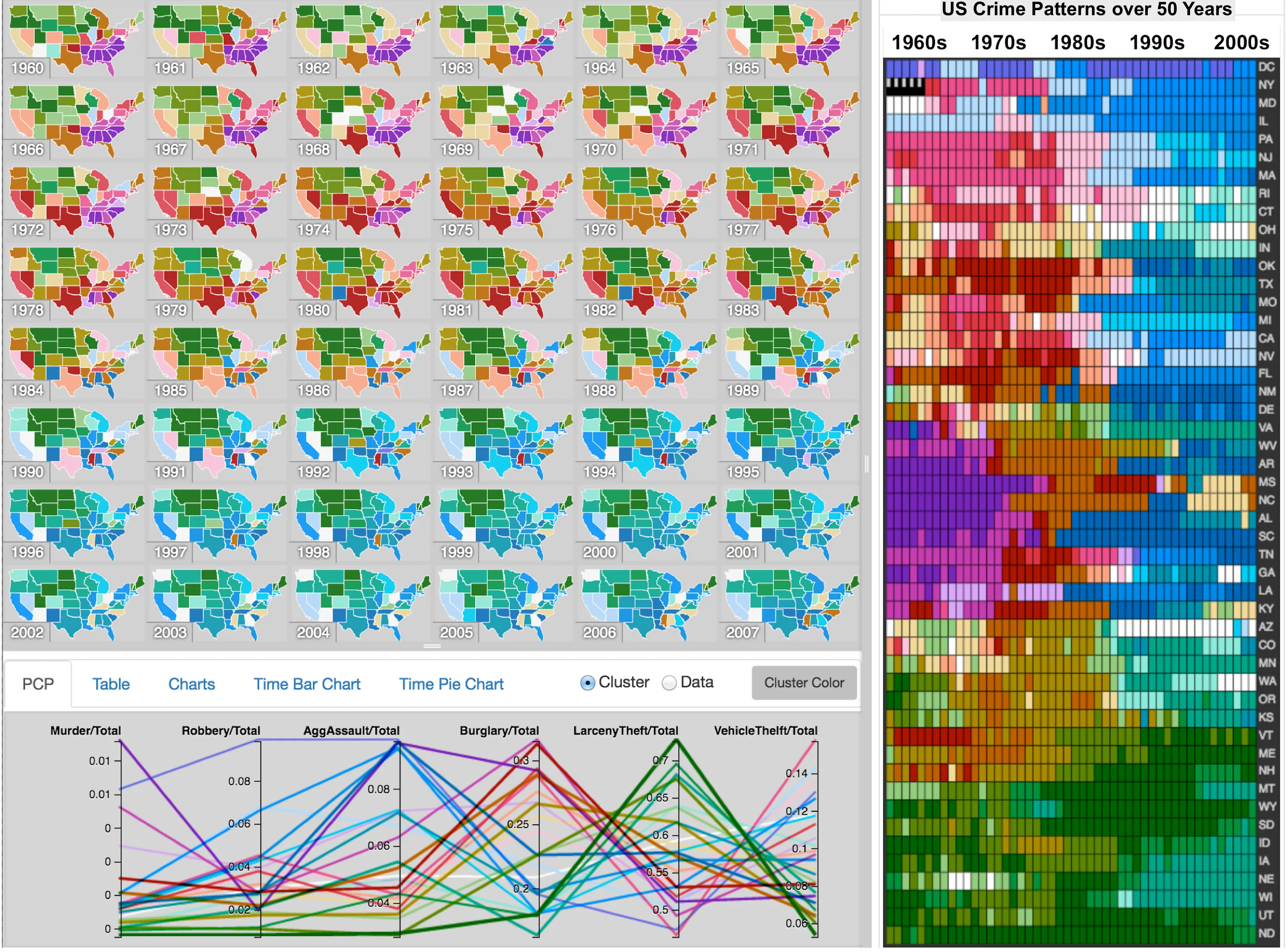
VIS-STAMP integrates computational analysis, interactive visualization, and cartographic design to reveal how multivariate patterns vary across places and change over time. It combines a Self-Organizing Map, parallel coordinate plots, reorderable matrices, geographic small multiples, optimal linear ordering, and a coordinated color scheme. These linked views and integrated methods allow analysts to move from an overview to detailed comparisons, identify trends and unusual patterns, and examine relationships that are difficult to discover through individual maps or statistical summaries.
Applications include analyzing technology-company trends, regional economic change, long-term crime patterns, and climate variation. More broadly, VIS-STAMP provides a framework for studying urban and regional change across multiple indicators, with potential applications in neighborhood development, public health, and environmental monitoring. Its central contribution is connecting computational pattern discovery with visual reasoning so that analysts can interpret changes in their geographic and temporal context.
Related Publications
A Visualization System for Space-Time and Multivariate Patterns (VIS-STAMP). IEEE Transactions on Visualization and Computer Graphics , 12(6), 1461–1474
BibTeX
@article{guo2006visualization,
  author = {Guo, Diansheng and Chen, Jin and MacEachren, Alan M. and Liao, Ke},
  title = {A Visualization System for Space-Time and Multivariate Patterns (VIS-STAMP)},
  journal = {IEEE Transactions on Visualization and Computer Graphics},
  year = {2006},
  volume = {12},
  number = {6},
  pages = {1461--1474},
  publisher = {Institute of Electrical and Electronics Engineers (IEEE)},
  doi = {10.1109/tvcg.2006.84},
  url = {https://doi.org/10.1109/tvcg.2006.84},
} Spatial ordering and encoding for geographic data mining and visualization. Journal of Intelligent Information Systems , 27(3), 243–266
BibTeX
@article{guo2006spatial,
  author = {Guo, Diansheng and Gahegan, Mark},
  title = {Spatial ordering and encoding for geographic data mining and visualization},
  journal = {Journal of Intelligent Information Systems},
  year = {2006},
  volume = {27},
  number = {3},
  pages = {243--266},
  publisher = {Springer Science and Business Media LLC},
  doi = {10.1007/s10844-006-9952-8},
  url = {https://doi.org/10.1007/s10844-006-9952-8},
} Visual analytics of spatial interaction patterns for pandemic decision support. International Journal of Geographical Information Science , 21(8), 859–877
BibTeX
@article{guo2007visual,
  author = {Guo, D.},
  title = {Visual analytics of spatial interaction patterns for pandemic decision support},
  journal = {International Journal of Geographical Information Science},
  year = {2007},
  volume = {21},
  number = {8},
  pages = {859--877},
  publisher = {Informa UK Limited},
  doi = {10.1080/13658810701349037},
  url = {https://doi.org/10.1080/13658810701349037},
} Supporting the Process of Exploring and Interpreting Space–Time Multivariate Patterns: The Visual Inquiry Toolkit. Cartography and Geographic Information Science , 35(1), 33–50
BibTeX
@article{chen2008supporting,
  author = {Chen, Jin and MacEachren, Alan M. and Guo, Diansheng},
  title = {Supporting the Process of Exploring and Interpreting Space–Time Multivariate Patterns: The Visual Inquiry Toolkit},
  journal = {Cartography and Geographic Information Science},
  year = {2008},
  volume = {35},
  number = {1},
  pages = {33--50},
  publisher = {Informa UK Limited},
  doi = {10.1559/152304008783475689},
  url = {https://doi.org/10.1559/152304008783475689},
} Understanding Climate Change Patterns with Multivariate Geovisualization. 2009 IEEE International Conference on Data Mining Workshops , 217–222
BibTeX
@inproceedings{jin2009understanding,
  author = {Jin, Hai and Guo, Diansheng},
  title = {Understanding Climate Change Patterns with Multivariate Geovisualization},
  booktitle = {2009 IEEE International Conference on Data Mining Workshops},
  year = {2009},
  pages = {217--222},
  publisher = {IEEE},
  doi = {10.1109/icdmw.2009.91},
  url = {https://doi.org/10.1109/icdmw.2009.91},
} Understanding Spatiotemporal Patterns of Multiple Crime Types with a Geovisual Analytics Approach. Crime Modeling and Mapping Using Geospatial Technologies
BibTeX
@incollection{guo2013crime,
  author = {Guo, Diansheng and Wu, Jiang},
  title = {Understanding Spatiotemporal Patterns of Multiple Crime Types with a Geovisual Analytics Approach},
  booktitle = {Crime Modeling and Mapping Using Geospatial Technologies},
  year = {2013},
  pages = {367--385},
  publisher = {Springer Netherlands},
  doi = {10.1007/978-94-007-4997-9_16},
  url = {https://doi.org/10.1007/978-94-007-4997-9_16},
}
Software Download
Download the latest release package for VIS-STAMP: Visualization for Space-Time and Multivariate Patterns: